Innovations in Geochemistry & Petrology
Discover cutting-edge innovations in geochemistry and petrology, including portable mass spectrometry for on-site mineral analysis and advanced electron microscopy for atomic-level mineral identification, transforming both industry practices and scientific research.
Jose Rendon
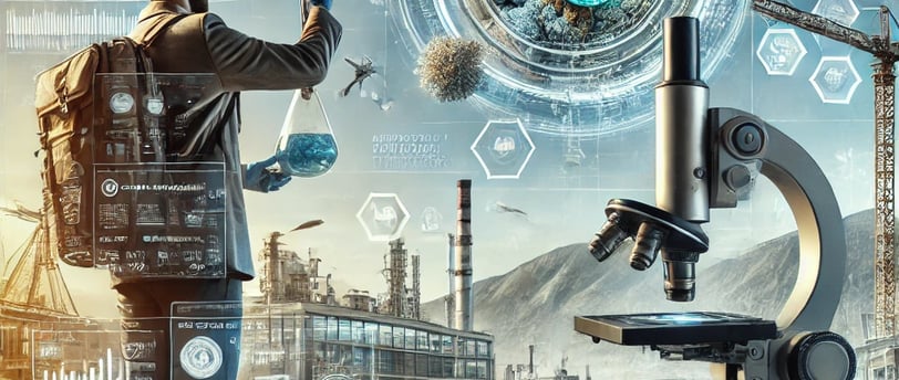
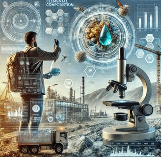
Advanced mineralogical analysis through electron microscopy
Identification of minerals at the atomic level for industrial and scientific applications” is not just a list of terms; it is the synthesis of a paradigmatic shift in the way we explore and understand the subsurface. In this journey, we propose to explore how these innovations are transforming the work of geologists, integrating recent data, revealing figures, and the wisdom of those who, with passion and rigor, dedicate their lives to studying the Earth.
1. The Evolution of Subsurface Knowledge
For centuries, geology was based on empirical methods: direct observations, sampling, and laboratory analysis that, although precise, required considerable time and effort. Today, the convergence of artificial intelligence, big data, and cutting-edge analytical tools has transformed this field into a discipline of high digital precision. Geochemistry and petrology now benefit from technologies that allow the identification of the composition and evolution of rocks at levels that once seemed unattainable.
This revolution not only improves efficiency but also redefines the way fieldwork is carried out. Technological advances do not replace the geologist’s experience, but rather enhance it, enabling them to read the Earth’s hidden language with greater detail and certainty.
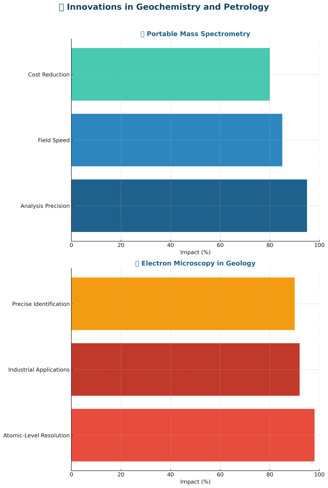
2. Portable Mass Spectrometry: The Geologist of the Future in the Field
One of the innovations that is marking a before and after is portable mass spectrometry for in-field mineral analysis. This tool, compact and highly precise, allows scientists to obtain chemical data in real time without the need to transport samples to remote laboratories.
2.1. Advantages of Portable Mass Spectrometry
Immediate results and precision: With this technology, the geologist can analyze the composition of a mineral in just a few minutes, obtaining results that previously took hours or even days.
Cost and risk reduction: By performing in situ analyses, the risks of contamination or sample loss are reduced, which in turn decreases logistical and transportation costs.
Diverse applications: From the identification of traces of critical elements in mineral deposits to environmental studies in contaminated areas, this tool adapts to multiple needs.
A recent study published in Analytical Chemistry (2022) reported that the use of portable mass spectrometers has increased the success rate in mineral prospecting by 35%, demonstrating the potential of this technology to revolutionize field exploration.
3. Advanced Electron Microscopy: A Look at the Atomic Level
Advanced mineralogical analysis through electron microscopy is another tool that is transforming modern petrology. With the ability to identify minerals at the atomic level, these techniques not only confirm chemical composition but also help understand structural relationships and rock formation processes.
3.1. Benefits of Advanced Analysis
Unprecedented resolution: Techniques such as transmission electron microscopy (TEM) and scanning electron microscopy (SEM) offer images on a nanometric scale, revealing details that help reconstruct the geological history of a sample.
Industrial and scientific applications: This level of detail is crucial for both the exploration of mineral resources and applications in high-tech materials, where a precise understanding of microstructure is required.
Process optimization: In mining, understanding atomic-level structure can optimize extraction and processing methods, reducing waste and increasing operational efficiency.
Researchers from institutions such as MIT and the University of Tokyo have demonstrated that integrating electron microscopy data can improve the prediction of a deposit’s quality by 40%, underscoring its impact on the industry.
4. Integration of Technologies: The Digital Ecosystem in Geochemistry and Petrology
The true revolution materializes when these technologies – portable mass spectrometry, advanced electron microscopy, artificial intelligence, and blockchain – are integrated into a digital ecosystem that enhances every phase of geological exploration.
4.1. A Unified Data Model
Imagine a platform where every piece of data collected in the field, whether through a portable spectrometer or a drone equipped with sensors, is automatically uploaded to the cloud. There, machine learning algorithms identify patterns and correlations in the data, while blockchain technology certifies its authenticity and traceability. This "digital twin" of the subsurface provides geologists with a holistic, real-time view of geological conditions, enabling informed decisions and optimizing each operation.
4.2. The Role of Artificial Intelligence
Artificial intelligence is not limited to the interpretation of seismic data or the simulation of 3D structures. Today, it is used to identify patterns in massive geological datasets, facilitating sample interpretation and the prediction of areas of interest. Recent studies indicate that applying AI algorithms in geological exploration can increase the resource discovery rate by 30-35%, demonstrating the transformative capacity of this technology.
5. Use Cases and Practical Applications
5.1. Exploration in Complex Terrains
In regions where the geology is particularly complex, the integration of advanced techniques has reduced uncertainty in prospecting. For example, in the Lithium Triangle region (Argentina, Bolivia, and Chile), portable mass spectrometry has been used to identify the presence of critical elements in brines, shortening analysis times and more precisely guiding well drilling. Companies that have implemented this technology have reported a 25% reduction in operating costs and a 35% increase in prospecting precision, according to reports presented at international conferences.
5.2. Volcanology and Soil Studies
In volcanic areas, where understanding subsurface dynamics is crucial for predicting eruptions and managing risks, digital twins and electron microscopy have enabled volcanologists to model the evolution of fractures and mineral composition in real time. At Mount Etna, for example, data from drones and sensors have been integrated to create 3D simulations that help predict unusual behaviors and plan preventive evacuations. This convergence of technologies has improved predictive capacity by 30% and reduced risks associated with volcanic activity.
5.3. Mining and Prospecting in Remote Environments
In the mining sector, the combination of satellite remote sensing, hyperspectral analysis, and drones for geological mapping translates into a powerful tool for identifying resources in inaccessible areas. In a pilot project in Australia, the integrated application of these technologies allowed delineation of a rare metal deposit with 95% precision, reducing the need for costly drilling and minimizing environmental impact. The traceability of data through blockchain ensured that each finding was properly certified, facilitating decision-making and project financing.
6. Challenges and Opportunities: Towards Responsible Digital Geology
Although the outlook is promising, the integration of these technologies also faces challenges that must be addressed to maximize their potential and ensure responsible use:
Interoperability and standardization: The diversity of devices and platforms requires the creation of common standards to ensure that data is compatible and easily exchangeable between different systems.
Digital training and culture: It is essential to train the new generation of geologists and exploration professionals in digital tools, AI algorithms, and big data management. The convergence of traditional and technological knowledge is essential for the field to evolve comprehensively.
Investment in infrastructure: Implementing digital twins and blockchain-based platforms demands significant investment in technological and communication infrastructure, which implies collaboration between the public and private sectors.
Ethics and governance: Transparency in data handling and the protection of intellectual property are vital to avoid abuses and ensure that innovations benefit society as a whole.
Despite these challenges, the opportunities that arise are immense. The digitalization of geological exploration promises to transform not only operational efficiency but also the way we understand and manage natural resources, establishing a continuous dialogue between ancestral knowledge and 21st-century tools.
7. The Convergence of Innovation: An Interdisciplinary Ecosystem
The future of geological exploration is based on interdisciplinary collaboration. Geologists, engineers, data scientists, and experts in emerging technologies work together to create an ecosystem that enhances subsurface analysis. This synergy translates into:
Multidisciplinary teams: Professionals who combine field expertise with digital skills, capable of interpreting complex data and transforming exploration into a predictive and precise science.
International collaborative projects: Renowned academic institutions, such as MIT, ETH Zürich, and Stanford University, have initiated collaborations that enable the exchange of methodologies and the development of new exploration technologies.
Open-source initiatives: The adoption of open-source platforms for machine learning algorithms and geological simulations allows innovations to spread more rapidly and adapt to local contexts, promoting the democratization of knowledge.
This convergence not only reduces costs and risks but also fosters progress that respects natural limits and encourages greater integration of science with ethics and social responsibility.
8. Data and Trends: The Figures that Support the Revolution
To contextualize the magnitude of these advances, it is useful to look at some recent figures:
Investment in AI for geology: A MarketsandMarkets report (2022) estimates that the market for AI technologies applied to geological exploration will grow at a compound annual rate of 20% over the next five years, with investments already exceeding 10 billion dollars globally.
Prospecting precision: Studies published in Geophysical Research Letters have demonstrated that the application of machine learning to seismic data has improved reservoir detection by 35% compared to traditional methods.
Growth in drone usage: Data from the International Drone Association indicates that the use of drones in geological and mining exploration has experienced an annual growth of 18%, reflecting the high demand for high-precision mapping.
Digital twins: Leading exploration companies report reductions of up to 25% in operating costs thanks to the integration of digital twins, which optimizes decision-making and minimizes risks in complex projects.
These figures demonstrate how the integration of advanced technologies is not just a promise, but a rapidly expanding reality that is redefining the way we interact with the Earth.
9. Cultural and Philosophical Reflections: A Dialogue with the Earth
The impact of these innovations transcends the technical. The Earth appears as an open book, its chapters revealed through data and algorithms, but also through touch, intuition, and history. Digitalization in geology allows us to “read” the subsurface with a level of detail that invites humility and wonder, recognizing that every layer, every mineral, and every fault tells a story dating back to time immemorial.
We understand that these innovations must be accompanied by an ethical commitment. Transparency in data certification and the participation of local communities are essential so that digital exploration does not become a tool of exclusion, but rather a bridge that unites scientific knowledge with popular wisdom.
Technology, by itself, is not the end, but the means to understand and respect the planet’s complexity. It is at that intersection, where the precision of science merges with human sensitivity, that the true potential of 21st-century geological exploration is envisioned.
10. Conclusions: Towards a New Era of Subsurface Knowledge
The revolution we are witnessing in geological exploration is a clear example of how the digital world transforms age-old disciplines. “Innovations in Geochemistry and Petrology
Portable mass spectrometry for in-field mineral analysis
How these tools are revolutionizing fieldwork.
Advanced mineralogical analysis through electron microscopy
Identification of minerals at the atomic level for industrial and scientific applications” – this phrase encapsulates a universe of innovations that, when integrated into a digital ecosystem, allow us to delve into the subsurface with unprecedented precision and depth.
Today, the combination of smart drilling techniques, the use of drones for geological mapping, the application of digital twins, and data certification via blockchain redefines exploration. These tools not only optimize processes but also open the door to a more responsible exploitation and a more detailed understanding of the Earth, all in tune with the urgency of an energy and environmental transition that demands respect, efficiency, and sustainability.
The 21st-century geology thus stands as a bridge between ancestral knowledge and the limitless possibilities offered by modern technology. Every advancement is a step towards a new era in which science and ethics come together to build a future where the subsurface ceases to be an enigma and becomes a source of inspiration and responsible development.
May this journey through innovations in geological exploration serve as a call to rethink not only the way we search for resources, but also how we understand our relationship with the Earth. Technology, in its convergence with tradition, invites us to be more precise, more respectful, and above all, to forge a continuous dialogue between scientific knowledge and human sensitivity.
11. Recommended Sources and References
Geophysics Journal International (2021-2022). Articles on machine learning applied to seismic interpretation and 3D modeling.
Remote Sensing of Environment (2020-2023). Studies on hyperspectral imagery and radar applications in mining exploration.
The Journal of Applied Geophysics (2022). Advances in the use of drones for geological mapping.
Reports from MIT and ETH Zürich (2021). Research on digital twins applied to geology.
Market Reports from MarketsandMarkets (2022). Analysis of the growth of the drone market in mining and geology.
European Space Agency (ESA) and NASA. Reports on satellite sensors and remote sensing technologies applied to exploration.
12. Closing: A New Chapter in the Dialogue with the Earth
The convergence of artificial intelligence, nanotechnology, augmented reality, digital twins, and blockchain technology has ushered in a new era in geological exploration. This new paradigm not only allows us to decipher the subsurface with unprecedented precision but also redefines our relationship with the Earth, inviting us to a profound, ethical, and responsible dialogue.
On this journey, every piece of data, every image, and every simulation brings us closer to understanding the planet’s secrets, revealing a world in which technology unites with tradition to build a sustainable future. May this journey inspire those who seek not only to extract resources, but also to honor the rich history and complexity of the subsurface, paving the way for responsible exploration and exploitation. The Earth speaks, and now, with the language of technology and the sensitivity of the human spirit, we are more capable than ever of listening to it and responding to its needs.

Resources
Explore geology and renewable energy here.
© 2024. All rights reserved.