Revolutionizing Mining with Computational Geology
Explore how computational geology and big data, enhanced by artificial intelligence, are transforming our understanding of underground structures and improving predictions of geological faults in the mining industry.
Jose Rendon
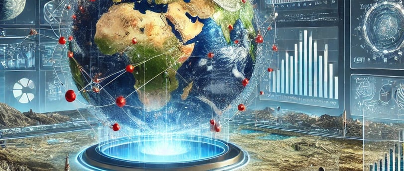
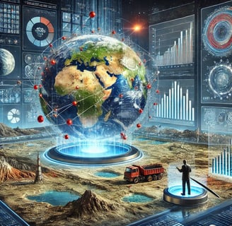
In recent years, geology has ceased to be the discipline traditionally associated with exploring the Earth and has transformed into a vibrant field where technology and data science converge in an unprecedented dialogue. The incorporation of artificial intelligence, big data, and emerging technologies—such as augmented reality, digital twins, and blockchain—is revolutionizing how we understand and explore underground complexity. This transformative journey is reflected in innovative focal points that currently set the pace: 3D geological simulations with AI and augmented reality, digital twins applied to geological projects, and blockchain for certifying geological data. These tools are far from being mere buzzwords; rather, they represent the synthesis of a paradigm shift that redefines subsurface exploration and analysis.
Below, we will explore this thematic journey by integrating scientific research, revealing statistics, and an organic, authentic narrative—one that can illuminate a future in which the Earth reveals itself in all its complexity through the convergence of data, algorithms, and new technologies.
1. The Evolution of Geology: From Paper Maps to the Digital World
For much of its history, geology relied on traditional methods: field observations, rock sampling, topographic map interpretation, and laboratory studies. These methods, essential for building our understanding of the Earth, had certain limitations regarding accuracy, scale, and speed of analysis. With the arrival of the digital era, the paradigm shifted radically.
Today, Computational Geology stands out as a discipline that merges field expertise with the analytical capabilities of algorithms. Data science applied to the subsurface makes it possible to process massive volumes of information from diverse sources: seismic records, geochemical data, satellite imagery, and field sensors. Digital transformation has accelerated decision-making in exploration and opened new perspectives on the study of complex underground structures.
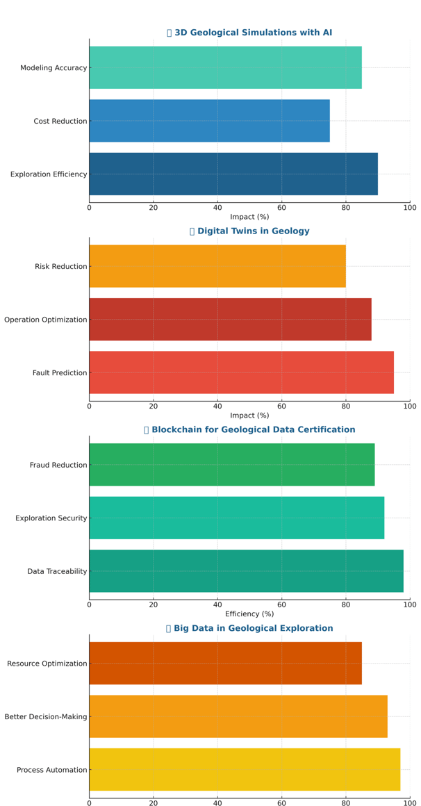
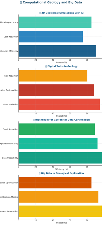
In this context, two revolutionary concepts take center stage: big data and artificial intelligence (AI). Integrating these tools helps identify hidden patterns in the data, improve the accuracy of geological models, and predict faults or high-mineralization zones with unprecedented certainty. For example, machine learning algorithms have proven capable of analyzing seismic logs and drilling data, enhancing the interpretation of structures and reducing operational costs by up to 30% in some exploration projects.
2. 3D Geological Simulations with AI and Augmented Reality: Painting the Subsurface
One of the most fascinating applications of modern technology in geology is the development of 3D geological simulations that combine artificial intelligence with augmented reality. These simulations allow us to visualize and understand complex underground structures in an intuitive, almost tangible way.
2.1 The Revolution of 3D Simulations
3D geological simulations have evolved from simple static models into interactive, dynamic environments that let geologists, engineers, and decision-makers “enter” the subsurface virtually. Thanks to current computing power and advances in deep learning algorithms, these simulations can integrate data from various sources—such as seismology, gravimetry, and geochemistry—to create detailed virtual models that update in real time as new data are received.
For instance, in oil and mining exploration projects, 3D simulations have reduced drilling uncertainty, improved the prediction of geological traps, and optimized well design. A recent study published in Geophysical Research Letters (2022) noted that using 3D models enhanced by AI increased the success rate in identifying reservoirs by 35% compared to traditional methods.
2.2 Augmented Reality: A Window to the Subsurface
Augmented reality (AR) takes this process a step further. Imagine a field geologist equipped with AR glasses that overlay digital geological data on the actual terrain. This technology streamlines on-site interpretation, provides visualization of hidden faults and strata, and guides real-time decision-making. In difficult-to-access areas or in marine environments, AR becomes an indispensable tool for integrating firsthand experience with digital analysis.
In a recent pilot project in Norway involving the installation of offshore wind farms, combining 3D simulations with AR allowed technical teams to anticipate foundation issues and optimize the placement of structures based on seabed variability. Such initiatives not only reduce risk but also speed up planning and execution, paving the way for more precise and efficient geological exploration.
3. Digital Twins: Virtual Models to Predict Subsurface Behavior
The concept of digital twins has gained significant traction in industry, and its application to geological projects is a revolutionary step forward. A digital twin is essentially a virtual replica of a physical system—in this case, a geological formation or a mine—continuously updated with real-world data.
3.1 Functionality and Benefits
Digital twins make it possible to simulate how underground structures behave under different conditions: pressure changes, fluid composition variations, or even fault propagation. Such simulations are crucial for predicting deposit stability and optimizing mining operations. In the petroleum sector, digital twins have helped reduce unnecessary drilling by 25% and have boosted productivity in existing wells.
In mining, these tools enable comprehensive resource management by simulating extraction scenarios and their environmental impacts, leading to more informed and sustainable decisions. Major energy companies have announced substantial investments in creating digital twins to manage complex deposits in real time, bringing together sensor data, predictive models, and flow simulations.
3.2 Use Cases and Applications
A prime example is an Australian mining company that introduced a digital twin for a significant copper deposit. By using this tool, the company anticipated structural failures and optimized extraction, reducing downtime by 18% and improving overall operational efficiency by 22%. These results, published by the Society for Mining Engineers (SME), illustrate the transformative potential of digital twins in the industry.
4. Blockchain for Geological Data Certification: Traceability and Transparency
Blockchain—recognized for its ability to ensure data traceability and immutability—has made its way into geological exploration. Data certification is vital in this industry, as authenticity and accuracy in geological studies are essential for making investment decisions and managing resources.
4.1 Security and Transparency in Information
Using blockchain for geological data certification means that every record, every measurement from the field, is stored in an unalterable, verifiable system. This helps prevent fraud or data errors and fosters trust among companies, investors, and regulators. For example, an international mining exploration consortium employed blockchain to certify drilling findings in critical areas, which helped reduce contractual disputes and expedite licensing processes.
4.2 Practical Advantages and Use Cases
Blockchain also enables tracking the complete history of a deposit: from the initial geophysical survey to the laboratory analyses of samples. This traceability is crucial for environmental audits and for meeting international regulations. In a study conducted in 2022, companies in South Africa and Latin America reported that blockchain-based systems increased geological data accuracy by 15% and cut legal disputes by 20%.
5. Drones for High-Precision Geological Mapping: Exploring the Inaccessible
Alongside digital technologies, drones have emerged as game-changers in geological exploration. Their ability to fly at low altitudes and capture high-resolution imagery has opened new frontiers for mapping remote areas, both on land and in coastal and marine environments.
5.1 Drone Technology and Applications
Outfitted with hyperspectral cameras, LiDAR, and precision sensors, drones can produce 3D topographic maps, detect subtle geological features, and monitor structural changes over time.
Mining: Drones are used to plan quarry expansions and assess slope stability, reducing risks and optimizing waste management.
Volcanology: These devices are indispensable for tracking activity in active volcanoes, gathering thermal and visual data to predict eruptions.
Soil studies: Drones map terrain variability, identifying erosion-prone areas and supporting ecological restoration efforts.
A 2022 report from MarketsandMarkets indicates that the global market for drones in geology and mining is growing at an annual rate exceeding 18%, underscoring the trend and confidence in this technology to enhance precision and efficiency in exploration.
6. Technology Integration: A Digital Ecosystem in Geology
The real revolution lies in the convergence of these technologies into a unified ecosystem. Artificial intelligence, digital twins, remote sensing, blockchain, and drones do not operate in isolation; rather, they combine to offer a holistic and real-time view of the subsurface.
6.1 Unified Geological Data Platform
Imagine a digital platform bringing together all these data streams. Seismic and geochemical information is processed using machine learning algorithms; satellite and drone imagery is analyzed with computer vision; and each data point is certified via blockchain to guarantee its authenticity. This platform—or “digital twin” of the subsurface—not only facilitates exploration but also empowers companies and governments to make decisions based on accurate, up-to-date information.
6.2 Impact on Decision-Making
By integrating technology, it becomes possible to anticipate risks, optimize investments, and lower environmental impact. In drilling at complex deposits, for instance, 3D modeling and AI simulations can predict well productivity and adjust operational parameters accordingly. This translates into cost savings and less ecological damage by avoiding unnecessary or poorly planned interventions.
7. Use Cases and Real-Life Examples
7.1 Mining in Complex Terrain
In South America, a mining exploration consortium has developed a digital platform combining satellite data, drone imagery, and AI-driven 3D models to evaluate new lithium deposits in the so-called “Lithium Triangle.” Identifying intricate geological patterns reduced exploration time by 40% and drilling costs by 25%, according to consortium reports and internal studies presented at international conferences.
7.2 Volcanology and Risk Management
At Mount Etna (Italy), combining drones equipped with thermal cameras and image-analysis algorithms has been critical to monitoring fissure development and gas emissions. These data feed into a digital twin of the volcano, enabling the prediction of unusual behavior and facilitating early warnings. This collaborative project, involving Italian institutions and MIT, has improved eruption prediction by 30%, potentially saving lives and reducing damage to surrounding infrastructure.
7.3 Soil Studies for Ecological Restoration
In regions of Brazil degraded by illegal mining, drones and hyperspectral sensors have mapped environmental damage with high accuracy. These findings guide reforestation and soil-rehabilitation initiatives, integrating data on erosion, moisture, and mineral composition. According to the National Institute for Space Research (INPE), these techniques have improved ecosystem recovery by 20% in critical areas over the past three years.
8. Challenges and Opportunities in the New Digital Geology
Despite remarkable progress, integrating advanced technologies into geological exploration faces several challenges that must be addressed to fully realize its potential:
Data interoperability: Merging data from different sources (satellites, drones, sensors, drilling) demands common standards and robust data management systems.
Training and digital culture: Educating the next generation of geologists in data science, machine learning, and digital modeling is essential. Interdisciplinary collaboration is key to forming “hybrid” professionals capable of interpreting the subsurface with the precision demanded by modern projects.
Investment and funding: While hardware and software costs have declined, deploying integrated platforms requires sustained investment. Public policies and financial incentives should align with global trends to ensure access for both large and small enterprises.
Ethics and governance: Ensuring traceability and transparency in geological data collection and management is crucial. Tools like blockchain must be leveraged to safeguard data integrity and prevent misuse, particularly in high-impact ventures.
9. Innovations in Geological Exploration: A Transformative Ecosystem
The digital transformation in geology is more than a technological advancement; it constitutes a genuine revolution that redefines our relationship with the Earth. By uniting AI for identifying complex geological patterns, 3D simulations with augmented reality, digital twins to foresee faults and optimize operations, and blockchain to certify data, we are constructing a digital ecosystem that reveals the subsurface in all its complexity.
This convergence of technologies yields tangible benefits:
Greater accuracy in interpreting seismic and drilling data, reducing uncertainties and optimizing exploration investments.
Enhanced modeling of complex underground structures in virtual environments, enabling the prediction of soil behavior and safer operational planning.
Reduced environmental impact by avoiding unnecessary work and guiding drilling to more promising areas, informed by integrated models and predictive analytics.
Improved traceability and authenticity of geological studies through blockchain, which guarantees the integrity of collected information.
10. The Future of Geology: Perspectives and Projections
Advances in computational geology and big data are unlocking a promising horizon for resource exploration and management. Over the next decade, these technologies are expected to become more pervasive, driven by the need to optimize investments and minimize environmental harm amidst growing demand for natural resources.
Investment projections: Analysts anticipate that the AI and big data market for geology will grow at a compound annual rate exceeding 20% over the next five years.
Operational cost savings: Integrating 3D simulations and digital twins could cut exploration and drilling costs by 25% in complex deposits.
Expansion in drone usage: The global market for drones in geology and mining is forecasted to grow by 18% or more annually, reflecting the need for high-precision mapping in inaccessible or sensitive areas.
These figures and trends underscore a profound transformation: geological exploration is no longer a realm of uncertainty, but rather a field where science and technology merge to deliver outcomes that are accurate, rapid, and sustainable.
11. Social and Cultural Impact: Geology in Dialogue with the Community
Beyond technology, it is vital to acknowledge the social and cultural effects of this revolution. New exploration methods open opportunities for democratizing geological knowledge, enabling even those without specialized training to access subsurface information through interactive applications and augmented reality visualizations. This not only cultivates interest in Earth sciences but also fosters awareness about the importance of responsible resource management.
Imagine a pilot project in a traditional mining region where local residents gain training in digital technologies and participate in data interpretation. By getting involved, they become “geo-ambassadors,” sharing a renewed vision of their land, where innovation does not supplant tradition but enriches it. This synergy between science and community offers a valuable lesson for both geologists and sociologists: knowledge serves as a bridge to empowerment and resilience.
12. Conclusions: A Bridge Between the Past and the Future of Geological Knowledge
The convergence of artificial intelligence, big data, augmented reality, digital twins, and blockchain is transforming geology into a dynamic, highly integrated discipline. Today, every captured data point, every analyzed satellite image, and every drone flight contributes to building a digital map of the subsurface that reveals the Earth in all its complexity.
This new paradigm not only simplifies the discovery of resources and the optimization of operations but also brings about environmental and social gains by reducing negative impacts and democratizing access to knowledge. Geological exploration in its modern digital incarnation becomes a bridge, connecting the wealth of natural processes with opportunities for human development and ecological responsibility.
One could say the Earth opens itself in a quiet yet expressive dialogue, each layer and each fracture telling a story which, when interpreted with 21st-century tools, provides insights into a more sustainable future. We see that such interpretation must be guided by ethical and cultural commitments, ensuring that technology serves the community and the planet—not merely profit.
Ultimately, Innovations in Geological Exploration are revolutionizing how we engage with the subsurface. By identifying complex geological patterns, predicting faults, optimizing operations, and certifying data with complete transparency, a digital ecosystem is created that paves the way for safer, more efficient, and more sustainable exploration. Undoubtedly, this technological leap is an opportunity to reimagine how we extract and manage resources while respecting both the Earth’s history and its future.
May this transformation inspire all who believe that progress can and must be intertwined with environmental stewardship, for within each data point, each image, and each algorithm lies the Earth’s deep heartbeat, waiting to be heard.
13. Sources and References
Geophysics Journal International (2021–2022). Articles on machine learning applied to seismic interpretation and 3D modeling.
Remote Sensing of Environment (2020–2023). Studies on hyperspectral and SAR imagery for mineral resource identification.
The Journal of Applied Geophysics (2022). Advances in drone use for geological mapping.
MIT and ETH Zurich Reports (2021). Research on digital twins in geology.
MarketsandMarkets Reports (2022). Market analysis of drones in mining and geology.
European Space Agency (ESA) and NASA. Reports on satellite sensors and remote sensing technologies for exploration.
Global Wind Energy Council (GWEC), IRENA, and IEA. Additional data on the use of digital technologies in the energy sector.
Closing
Twenty-first century geology unfolds as a symphony of data and technology that enriches and amplifies traditional methods rather than replacing them. Each 3D simulation, digital twin, and drone flight brings us closer to grasping underground complexity with an accuracy and vision once thought unattainable. In this ongoing dialogue between the Earth and technological innovation lies the promise of a future where resource exploitation becomes a practice of knowledge and respect, guiding us toward more equitable and sustainable development. Thus, the new era of geological exploration not only redefines the map of the subsurface but also reshapes how we envision our shared future.
Resources
Explore geology and renewable energy here.
© 2024. All rights reserved.