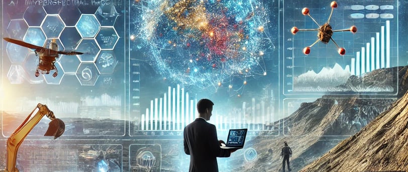
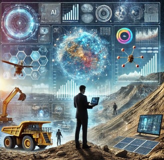
AI & Machine Learning in Geological Exploration
Discover how artificial intelligence and machine learning are transforming geological exploration by enhancing the analysis of seismic and drilling data. Learn about the role of satellite sensors, ...
Jose Rendon
1. Introduction: A Dialogue Between the Earth and Innovation
Let us imagine for a moment the silent heartbeat that runs through the Earth's strata, the ancient breath of minerals and rock formations that hold millennia-old secrets. Talking about geological exploration is, in a way, engaging in a conversation with the Earth, deciphering its hidden language while taking on the responsibility of understanding its rhythms and boundaries.
In a world that is rapidly moving towards digitization and artificial intelligence, this conversation with the Earth has become more complex and fascinating. Various emerging technologies—from machine learning to satellite sensors—are opening unforeseen horizons in the search for mineral and energy resources. However, this revolution is not without questions: How far can we go in responsible extraction? What are the ethical limits of underground resource exploitation? To what extent should—or can—precise geological information be reconciled with human needs?
Far from being merely a technical discipline, geology blends with culture and social responsibility. It encourages us to view the subsurface not as an inert reservoir but as a living and ever-changing entity.
At this crossroads of ideas and innovations, we must delve into the topic of Innovations in Geological Exploration: Artificial Intelligence to identify complex geological patterns, how machine learning is revolutionizing seismic and drilling data interpretation, satellite sensors and remote sensing for mining exploration—applications of hyperspectral imaging and radar in identifying mineral resources, and drones for high-precision geological mapping, with case studies in mining, volcanology, and soil studies. This set of tools and approaches, when properly orchestrated, forms the foundation of contemporary geological exploration, driving a deeper look into the heart of the Earth and, perhaps, towards the possibility of a more harmonious future between development and conservation.
This extensive text seeks to be an original and relevant contribution to understanding the magnitude of the transformation that geology is currently undergoing, with recent data and scientific reflections that provide a coherent overview, accessible to both curious readers and professionals in the field.
2. The Global Context: The Urgency of Responsible Exploration
Natural resources—particularly energy and mineral resources—have sustained modern civilization. From the oil that fueled the industrial revolution to the rare minerals essential for manufacturing electronic devices, geological exploration has been at the core of economic progress. However, the pressure on the subsurface is increasing at an accelerating pace, driven by:
Rising demand for critical metals: The rise of clean energy (solar panels, lithium-ion batteries, wind turbines) has increased the need for elements such as lithium, cobalt, nickel, copper, and rare earths. According to the World Bank, global demand for these minerals could multiply by 4 to 6 times in the next two decades.
The need for new hydrocarbon sources: While energy transition is being promoted, oil and gas still cover a significant portion of the global energy mix. The search for unconventional deposits and exploration in high-complexity areas (deep-sea regions, polar zones) requires advanced methodologies to minimize costs and environmental risks.
Regulations and social licenses: Society demands greater responsibility in resource exploitation. With the support of scientists and activists, stricter environmental impact assessments are being required, increasing the need for precise geological models to support decision-making.
This scenario calls for a qualitative leap in exploration techniques, where artificial intelligence, remote sensing, and drones are emerging as key players.
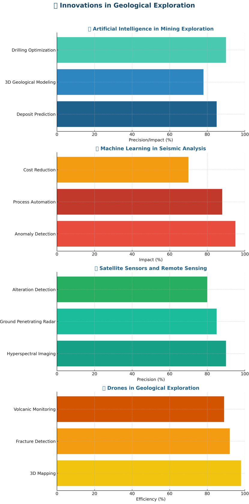
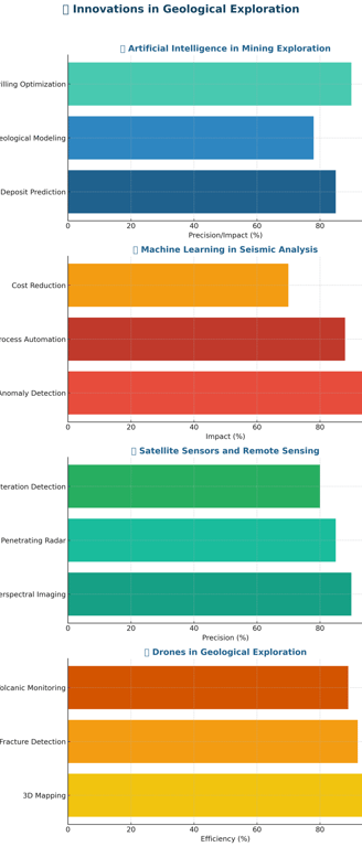
3. Artificial Intelligence for Identifying Complex Geological Patterns
Talking about artificial intelligence (AI) in geology may evoke images of algorithms that, like tireless detectives, scan geophysical and geochemical databases in search of hidden structures. Today, machine learning has become a fundamental tool in hydrocarbon and mineral exploration:
Seismic data interpretation: Large volumes of seismic records are processed using neural networks that detect discontinuities, potential structural traps, and sedimentary facies of interest. Precision in reservoir prediction has increased by 30% to 40% in some projects, according to Geophysics magazine (2022 edition).
Drilling well log analysis: Well logs generate thousands of data lines on electrical, sonic, radioactive, and petrophysical properties. Previously, their interpretation relied on relatively simple statistical models; now, machine learning identifies subtle correlations between layers and lithologies, allowing for more accurate formation characterization.
Risk and cost forecasting: In complex regions (such as ultra-deep waters or geologically unstable areas), machine learning helps reduce drilling uncertainty, preventing leaks or accidents that could increase costs and damage the environment.
It is significant to note how this geological AI thrives on the collaboration between traditional geologists (experts in field analysis) and data scientists (specialists in algorithms). This synergy, if combined with the necessary prudence and ethics, enables a more accurate and less invasive approach to subsurface exploration, addressing sustainability demands.
4. Remote Sensing and Satellite Sensors: The View from Orbit
Remote sensing is another cornerstone of contemporary geological exploration. The development of satellites equipped with high-resolution cameras and multi- and hyperspectral sensors provides a panoramic view of the Earth's surface, useful for identifying mineralogical alterations, structures, and fundamental geological features:
Hyperspectral imaging: Capable of distinguishing hundreds of spectral bands, it reveals the spectral signature of different minerals. This allows for the preliminary mapping of elements such as iron oxides, clays, or carbonates. For instance, the Canadian company MacDonald, Dettwiler and Associates (MDA) and NASA have developed sensors that detect anomalous mineralizations in arid regions, accelerating the location of metallic deposits.
Synthetic Aperture Radar (SAR): Allows penetration through clouds and data collection even in adverse weather conditions or at night. SAR is highly valuable for mining exploration in forested or humid areas, as it provides precise topographic information and detects millimeter-scale ground deformations associated with faults or underground collapses.
Monitoring of dams and tailings ponds: Although not directly related to resource exploration, geotechnical applications for mining infrastructure safety benefit from remote sensing: satellite systems such as Sentinel-1 (from the European Space Agency) monitor slope stability and tailings deposits, preventing socio-environmental disasters.
These technological tools, however, require rigorous interpretation. The abundance of data does not replace the geological expertise of field professionals, who, with their trained eyes, combine satellite information with hands-on experience and direct observation of the rock.
5. Mining Exploration: Applications of Hyperspectral Imaging and Radar
The mining sector, in particular, has greatly benefited from remote exploration. In addition to reducing prospecting costs, it helps prevent unnecessary environmental impacts:
Lithium mining in salt flats: Regions of the Andes in Bolivia, Argentina, and Chile contain brine deposits rich in lithium. Remote sensing assists in distinguishing evaporation patterns and detecting underground water, narrowing down priority areas for sampling and minimizing the disruption of wetlands.
Detection of diamond-bearing kimberlites: Kimberlite fields in Africa or Russia, sources of diamonds, are often buried under sedimentary layers. The combination of radar and multispectral imaging helps detect geochemical anomalies, facilitating the identification of kimberlite pipes.
Gold prospecting in tropical forests: Countries like Peru and Brazil suffer from illegal mining, which devastates forests and contaminates rivers with mercury. The use of hyperspectral satellites and mapping drones supports authorities and scientists in identifying deforestation hotspots and planning legal and sustainable exploration.
These applications demonstrate the transformative power of science and technology when the goal is moderate resource exploitation without causing irreversible damage to the environment or local communities.
6. Drones for High-Precision Geological Mapping: A New Paradigm
Perhaps the most visible leap in the last decade has been the emergence of drones (unmanned aerial vehicles) as high-precision geological mapping tools. Equipped with high-definition cameras, LiDAR, multispectral sensors, or even lightweight magnetometers, drones can access rugged or hard-to-reach areas, collecting data at an unprecedented level of detail:
Open-pit mining: To monitor excavation progress, slope stability, and dust control, drones generate up-to-date 3D models of the mining pit. This optimizes planning and reduces collapse risks.
Volcanology: Experts studying active volcanoes—such as Etna in Italy or Kīlauea in Hawaii—use drones to collect gas samples from craters and monitor early fissures. This increases safety by preventing volcanologists from being exposed to toxic gas concentrations.
Soil studies: In agricultural or ecological restoration areas, drones with hyperspectral cameras assess soil properties and erosion susceptibility. By generating moisture and composition maps, they help guide planting and conservation plans.
According to a MarketsandMarkets report (2022 edition), the global market for drones in geology and mining is growing at an annual rate of over 18%. This trend reflects the synergy between the need for high-quality data and the cost and risk reduction achieved through aerial robotics.
7. Use Cases: Mining, Volcanology, and Soil Studies
To delve deeper, it is worth highlighting some real-world applications that showcase the potential of these technologies:
"Greenland Minerals" Project: In remote Greenland, where extreme temperatures make fieldwork difficult, the combination of AI, remote sensing, and drones has enabled the mapping of intrusions rich in rare earth metals, critical for the electronics industry. This geological advancement reduces physical incursions into an extremely fragile polar ecosystem.
Monitoring the Fuego Volcano (Guatemala): Using drones equipped with gas sensors and thermal imaging, volcanologists analyze activity levels while minimizing personal risk. This allows for timely warnings to nearby communities about potential eruptions or pyroclastic flows.
Soil rehabilitation program in the Ruhr Basin (Germany): Historically industrialized, the basin suffers from soil contamination from metallurgical residues. Hyperspectral satellite analysis and drone flights identify areas with high concentrations of heavy metals, guiding bioremediation projects using hyperaccumulator plants.
8. Ethical Challenges and Cultural Perspectives in Geological Exploration
The adoption of such powerful technologies, however, is not without ethical challenges. We must reflect: Who controls and has access to the data generated by AI and remote sensing? Are the rights of local communities and Indigenous peoples living in resource-rich areas being respected?
The introduction of drones and satellites into regions where illegal mining or land disputes are ongoing can exacerbate conflicts if decisions are made without proper community participation. Companies, for instance, could explore from the air without local populations’ knowledge, fueling suspicions of opaque extractivism.
Thus, data governance and transparency in exploration projects are urgently needed. Authorities and companies alike must publish impact studies and geological data usage plans to prevent uncontrolled exploitation or rights violations. Geology, at its best, involves a dialogue with the land that goes beyond mere profit-seeking.
9. Synergies and the Future: An Innovation Ecosystem
The convergence of AI, satellite remote sensing, drones, and cutting-edge geophysical methods is shaping an innovation ecosystem where geological exploration becomes more precise, less invasive, and potentially more sustainable. In the industrial sphere, energy and mining companies are forming multidisciplinary teams that integrate:
Field geologists experienced in rock reading and local knowledge.
AI engineers and data scientists skilled in managing cloud-based machine learning algorithms.
Geophysics experts capable of interpreting seismic and magnetic profiles using advanced computational tools.
Drone pilots and technicians responsible for planning safe flights and collecting high-resolution 3D data.
Remote sensing specialists trained in photogrammetry, hyperspectral imaging, and synthetic aperture radar (SAR).
At the intersection of these disciplines, the role of the "geo-analyst" emerges—a hybrid professional who masters both exploration methods and classification algorithms, bridging traditional geology with the digital revolution. Advances in quantum computing and cloud storage could, in the next decade, exponentially accelerate geological data processing, opening up a landscape of possibilities that is only beginning to take shape.
10. Recent Data Reflecting the Magnitude of This Transformation
To reinforce the relevance of this wave of innovations in geological exploration, let’s consider some key figures:
A Deloitte (2021) study indicates that leading mining and energy companies have invested over $18 billion in AI and remote sensing over the past five years, with annual growth exceeding 20%.
The European Space Agency (ESA) reports that between 2020 and 2023, more than 25 private satellites dedicated to high-resolution Earth observation were launched, many focused on prospecting and environmental monitoring services.
The number of commercially registered drones for use in geology and mining increased by 35% in 2022, according to the International Drone Association (IADA).
These figures underscore the scale of investment and the industry's confidence in the digitization of geological exploration. If guided prudently, this trust could lead to reduced environmental impacts and better development decisions.
11. Final Reflections: Geology as a Bridge Between the Subsurface and Human Awareness
Geology, as a discipline, has been the backbone of resource exploration. However, in a world that urgently needs to balance the search for minerals and fuels with environmental conservation, geology is taking on an ethical and cultural dimension. The incorporation of artificial intelligence, remote sensing, and drones is not just a technical advancement—it is the promise that we can better understand our subsurface and ideally minimize damage when intervening.
We could conclude that this "conversation" with the Earth requires a particular kind of humility. It is not enough to map and extract; we need an approach that considers the finiteness of resources, the vulnerability of ecosystems, and the dignity of local populations. The land ceases to be merely a stage and becomes a network of histories and identities, where technology—if lacking sensitivity—can exacerbate inequalities.
In short, intelligent geological exploration provides a path to transform our relationship with the planet: a bond based on deep knowledge, moderation in exploitation, and intergenerational responsibility. May this repertoire of innovations—AI, satellite sensors, drones—serve the common good and harmony with nature, beyond the mere extractive drive. Perhaps then, science and technology will fulfill their promise of being bridges to a future where humanity and the Earth coexist in genuine synchrony.
12. References and Suggested Sources
Geophysics Journal International (2021-2022). Publications on the use of machine learning in seismic interpretation.
Remote Sensing of Environment (2020-2023). Studies on hyperspectral remote sensing in mineral prospecting.
The Journal of Applied Geophysics (2022). Advances in synthetic aperture radar for coastal geological exploration.
Reports from MIT and ETH Zurich (2021). Analysis of drones for geotechnical mapping and soil testing.
World Bank (2021). Minerals for Climate Action: The Mineral Intensity of the Clean Energy Transition.
MarketsandMarkets (2022). Reports on the growth of the mining and geology drone market.
Resources
Explore geology and renewable energy here.
© 2024. All rights reserved.